Studying New York’s Lake Ontario shoreline

Under contract with the New York State Office of General Services, Ramboll partnered with New York State Department of Environmental Conservation’s (NYSDEC) Great Lakes Program to design and implement the Lake Ontario Sediment Tracer Study, an applied, field-based effort to examine how coarse sediment (pebbles and cobbles) moves along the southeastern Lake Ontario shoreline. The study builds on existing research and aims to identify specific sources of coarse sediment, determine sand and gravel contributions, and understand how these materials shape and sustain the shoreline.
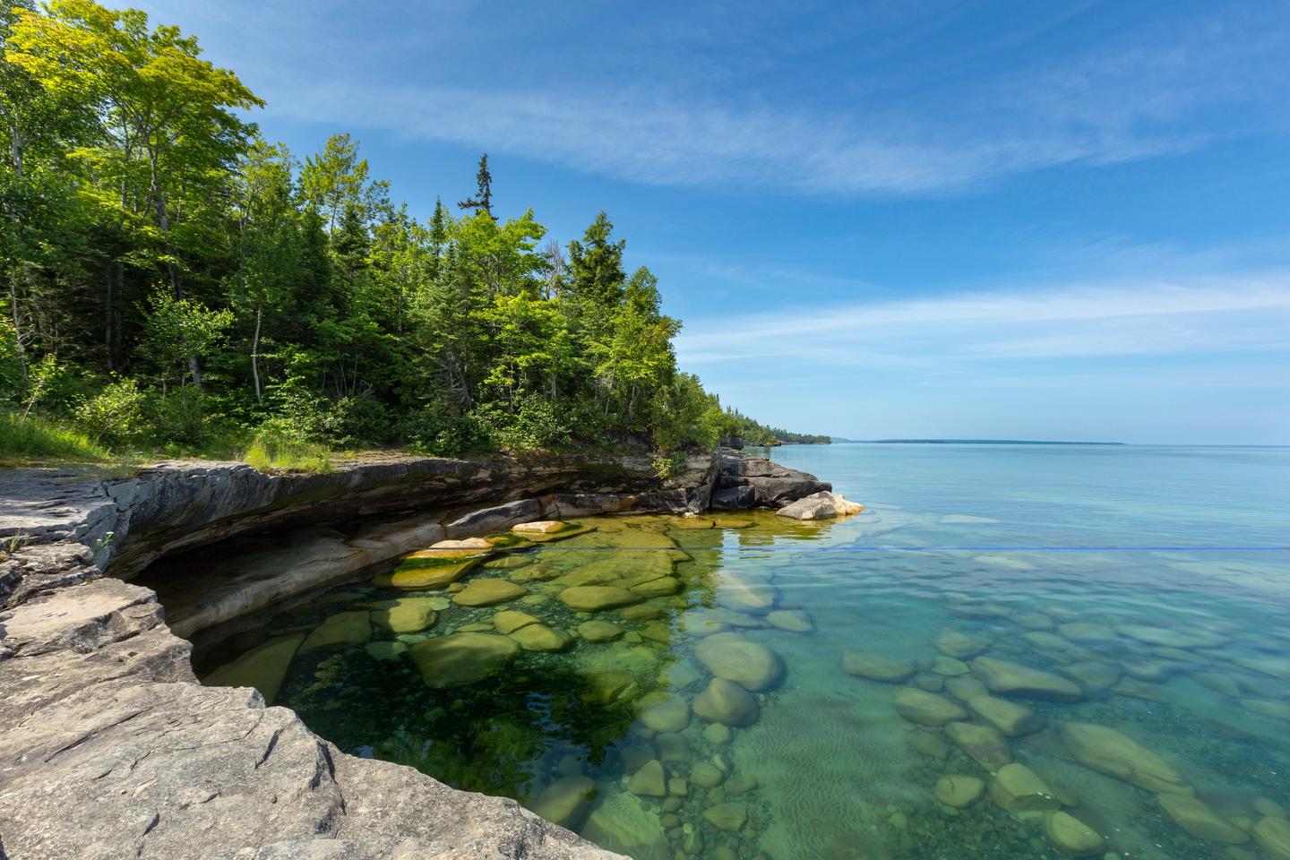
The Lake Ontario shoreline mainly consists of pebbles and cobbles and has large expanses of bluffs. These natural landscapes were formed by the movement and retreat of glaciers as well as the contemporary erosion of sediments by rain, slumping, and wave action. As a primary coarse sediment source, bluffs are essential to providing protection to the coastal communities along Lake Ontario. However, the function of bluffs as source areas has been disrupted by bluff stabilization (e.g., seawalls, revetments) as well as other coastal structures that inhibit the transport of coarse sediment from source to depositional areas, such as barrier bars, which play a key role as a natural protective feature along the shoreline. As a result of these disruptions, the risk to the shoreline and adjacent communities grows with each severe weather event.
Building the study
For the study, our team focused on two publicly accessible areas approximately 25 miles apart and in two separate counties: McIntyre’s Bluffs within Sterling Nature Center and Whistlewood Bluffs, which is more remote. These locations offered differing orientations and exposure, though each site includes a barrier bar segment. This allowed us to compare transport in front of bluffs versus along barrier bars.
To capture both event-scale and seasonal dynamics, we deployed two tracer types: painted tracers (0.5–1.5 rocks) to track short-term storm-driven movement, and RFID “smart rocks” (1.5–5 rocks) to track multimonth movement with a PIT tag reader and GPS. We also collected drone imagery to document beach and bluff evolution over the study period.
Tracking movement across the bluffs
Since the painted tracers would only show color for about five days, we tracked the movement of the painted rocks over a three-day period. With an east wind, the tracers moved 506 feet to the west at McIntyre’s and 809 ft at Whistlewood – approximately 150 to 250 feet per day. A second painted tracer monitoring event noted rates of movement upwards of 400 feet per day.
Because the smart rocks had a permanently installed PIT tag, we tracked them over five fall and winter months to allow us to study the effect ice and snow would have on the movement. Overall, the smart rocks showed maximum net movements of approximately 1,450 feet at McIntyre’s and 1,700 feet at Whistlewood, with a predominant eastward drift but measurable back‑and‑forth motion. We found that seasonal ice reduced rates of movement an order of magnitude. Our data also revealed that woody debris, especially downed logs, naturally trapped sediment and slowed movement at key locations, which helped to moderate erosion and sustain the natural protective functions of beaches and barrier bars.
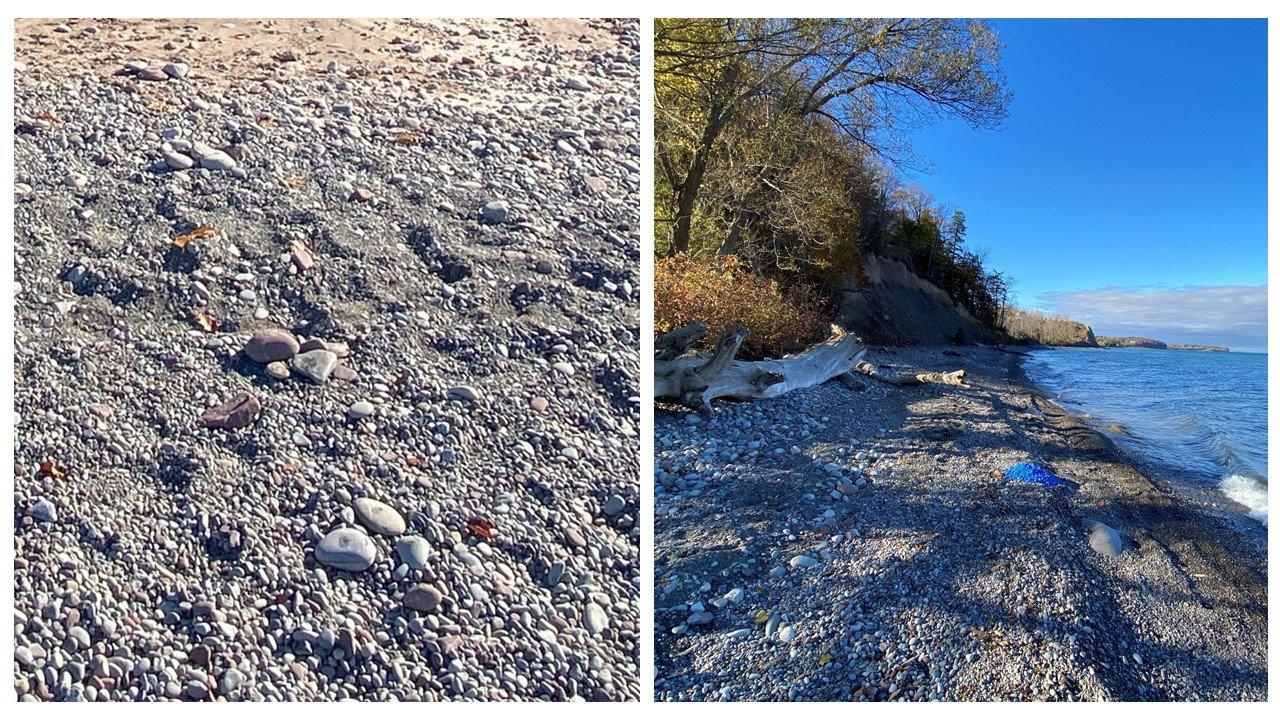
Smart rocks (left) and painted rocks (right)
Interpreting the data
Our research demonstrated the highly integrated nature of the shoreline and that decisions thousands of feet away can influence local conditions. Although western coarse sediment movement is relatively rare, but such movements can result in sediment becoming trapped when coastal designs do not take these movements into account, which can contribute to local erosion and potential breaches of barrier bars.
The data also showcased that natural structures and climate play a key role in safeguarding the coastline. Woody debris slowed down movement, suggesting that leaving it in place may help naturally moderate further erosion. While shoreline ice also helped to naturally moderate erosion, shoreline ice in the area has been decreasing over the last several decades. Thus, it is critical to plan proactively for continued warmer temperatures and less ice.
Our team will incorporate the findings into a synthesis report and provide recommendations for further coastal management.
Follow the smart rocks
You can see the movement of the rocks in both locations at the Lake Ontario Sediment Tracer Study Dashboard.
LEARN MORE
Building resilience across the Great Lakes
For decades, Ramboll has partnered across the Great Lakes to solve some of the region's most complex environmental challenges. By integrating expertise in remediation, sediment management, biodiversity, climate adaptation, water systems, resilient infrastructure, and ports and maritime development, Ramboll helps governments, industry, and communities protect critical freshwater resources while enabling sustainable economic growth.